One of our longtime collaborators, Trevor Wiens, has developed a new set of tools to assist Marxan users in creating Marxan input files, configure scenarios and import Marxan results. For more information visit ArcMarxan toolbox link, or QMarxan toolbox link.
PacMARA will be incorporating these tools into our Marxan training programs. If you are interested in our training programs please contact Norma Serra at nserra[at]pacmara.org
In January 2014, Heather Coleman and Ed Gregr of PacMARA were contracted by the North Pacific Research Board (NPRB) to facilitate a workshop in conjunction with the Alaska Marine Science Symposium.
The workshop had several overlapping goals: to 1) continue the two-way conversation between the NPRB and the social science community that was launched at the 2012 AMSS social science workshop, 2) provide an opportunity for the social science community to respond to approaches, challenges and opportunities raised in the NPRB-commissioned report, 3) discuss best practices/approaches for social science research that can help elevate quality and advance the science, and 4) discuss promising research directions, addressing issues raised in the report or other priority social science topics falling within the NPRB mission. The workshop was structured with a prospective outlook assessing the appropriate role for social science at NPRB.
The main product of the workshop was a report including recommendations for how NPRB should proceed in the social science realm. PacMARA also prepared an accompanying presentation that was shared at the spring 2014 board meeting.
Download the report and presentation here, or read more about NPRB’s natural and social science integration efforts here!
We are pleased to announce the release of six new videos in our Voices in Ocean Planning: Lessons from Leaders series!
You may learn about developing outreach materials for stakeholders, best practices for internal communication during an MSP process, communicating MSP through photos and maps, and many more tidbits of knowledge from leaders in the ocean planning field.
The Voices in Ocean Planning: Lessons from Leaders video series, produced by OpenChannels and PacMARA, offers wisdom and guidance on ocean management from experienced professionals in our field. You may view any of the 11 videos in the series at http://openchannels.org/videos/oc.
* Internal communication during an MSP process: David Beauchesne, Research Professional/Assistant Coordinator for a Feasibility Study for a MPA in the Magdalen Islands – Quebec, Canada
* Harmonizing spatial data: Jan Tjalling van der Wal, Researcher/MESMA Project Leader: Ecotoxicology, Wageningen IMARES – The Netherlands
* Building trust in a planning process: Karel Allard, Coordinator for Conservation Planning, Canadian Wildlife Service, Environment Canada – New Brunswick, Canada
PacMARA is holding an Introduction to Marxan technical training course and a Marxan for Managers workshop in Nairobi, Kenya on 13-15 May 2013. Please feel free to send this flyer to anyone who might be interested! And please register (details below) or contact hcoleman [at] pacmara.org if you would like to attend either or both events.
Rondinini et al. 20061. The two-day hands-on technical course will provide participants with the basic knowledge and skills necessary to use Marxan in a conservation planning exercise. The following topics are covered in Introduction to Marxan:
– Key concepts in systematic conservation planning
– Creating planning units
– Creating the essential Marxan input files with ArcGIS
– Parameter setting in Marxan
– Understanding and using Marxan results
– Zonae Cogito (front-end software to support Marxan)
– A brief introduction to Marxan with Zones
The course time will be split between lecture (~30%) and hands-on exercises (~70%). Experience with Arc or QGIS and MS Excel are prerequisite.Participants will need to bring a laptop with ArcMap 9 or 10 (and spatial analyst), or QGIS. Please contact us if you are interested in the course but cannot bring a laptop – we may have a few available for you to use with advanced notice.
The technical course will run from 9am – 5pm both days, and costs $675 with an $80 discount for early registrants (payment of $595 completed at least 2 weeks prior to the course). Contact us for possible student discounts. Registration information is at the end of this note.
Smith et al. 20082. The one-day Marxan for Managers workshop will provide a high-level background on marine and terrestrial systematic conservation and land/sea use planning, and will cover the questions of when, where, and why to use Marxan and other decision support tools. The interactive and discussion-based workshop will also cover:
– Key approaches and tools to conservation and resource planning
– Setting targets
– Stakeholder considerations
– Cost considerations
– Planning with uncertainty
However, each workshop will be tailored to specific interests, mandates, and problems of the group.We will highlight and explain essential elements of successful planning processes, provide case studies of initiatives around the world, and lead a discussion on approaches and good practices and managerial-level experience for systematic conservation and land/water use planning. This workshop is not technical and will not involve computers.
The workshop will run from 9am – 5pm, and costs $295 with a $45 discount for early registrants (payment of $255 completed at least 2 weeks prior to the course). Contact us for possible student discounts.
Location:
Both events will be held at the African Wildlife Foundation office in Karen, Nairobi (please visit this site for a map).
To register:
When you are ready for payment through paypal, please go to this site. Please register only when you are ready to pay with a credit card or through other paypal means (unless you are paying by check or cash, in which case contact us for details).
Note that it is not necessary for you to have a paypal account (click on “Don’t have a Paypal account?” towards the bottom of the page) to complete this process.
Refund policy:
Refunds will be given within two weeks of the course start date. Cancellations less than two weeks before the course will be refunded if we can replace the participant.
About Marxan:
Marxan (Ian Ball and Hugh Possingham, 2000) is a software program used to support the design of marine and terrestrial reserves worldwide. Using Marxan, planners can identify an efficient system of conservation sites that include a suite of biodiversity targets at a minimal cost. Marxan provides a unique method for designing reserves that is systematic and repeatable. It is the most used conservation planning tool worldwide; over 60 countries, 1100 users, and 600 organizations use Marxan to support the design of terrestrial and marine reserves. For example, it has been used to help zone the Great Barrier Marine Park, design marine reserves in the Channel Islands National Marine Sanctuary, and set spatial priorities in the Romanian Carpathians to protect large carnivores.
There are still some seats left for the Introduction to Marxan course on 24 – 25 June 2013, and the Advanced Topics course on 26 June 2013 in Victoria, Canada. Below is information about the course and workshop – please forward this to anyone who might be interested.
The two-day hands-on technical course will provide participants with the basic knowledge and skills necessary to use Marxan in a marine conservation planning exercise (also applicable to terrestrial and freshwater cases). The following topics are covered in Introduction to Marxan:
– Key concepts in systematic conservation planning
– Creating planning units
– Creating the essential Marxan input files with ArcGIS
– Parameter setting in Marxan
– Understanding and using Marxan results
– Zonae Cogito (front-end software to support Marxan)
– A brief introduction to Marxan with Zones
The course time will be split between lecture (~30%) and hands-on exercises (~70%). Experience with ArcGIS and MS Excel are prerequisite. Computers with ArcGIS 10 will be provided for participants unless you would like to bring a laptop.
The one-day interactive and discussion-based Advanced Topics in Marxan will provide a high-level background on marine and terrestrial systematic conservation and land/sea use planning, and it will cover topics such as:
– Data considerations
– Setting targets
– Stakeholder considerations
– Cost considerations
– Planning with uncertainty
The technical course runs from 9am – 4pm and costs $675, with a $80 discount for early registrants (payment of $595 completed at least 2 weeks prior to the course). The first five students to register will pay $375, and the next 5 students will pay $500. Lunch and coffee breaks are included and computers will be provided for participants (with ArcGIS 10).
The Advanced Topics course runs from 9am – 5pm and costs $150 (special rates may apply to students). Lunch and a coffee break are included.
Both events will be held at the Geography Department, University of Victoria.
When you are ready for payment, please go to this site: https://www.pacmara.org//events-workshops (please only register when ready to pay unless you are paying by check or cash, in which case contact us for details).
Note that we use paypal for registration, but it is not necessary for you to have a paypal account (click on “Don’t have a Paypal account?” towards the bottom of the page).
Cancellation Policy:
– Up to 2 weeks before a course: full refund less $30 admin fee
– 1-2 weeks before a course: 50% refund
– Less than 1 week before a course: no refund unless you can find a replacement for your space in the course (we will change names for no fee).
About Marxan:
Marxan (Ian Ball and Hugh Possingham, 2000) is a software program used to support the design of marine and terrestrial reserves worldwide. Using Marxan, planners can identify an efficient system of conservation sites that include a suite of biodiversity targets at a minimal cost. Marxan provides a unique method for designing reserves that is systematic and repeatable. It is the most used conservation planning tool worldwide; over 60 countries, 1100 users, and 600 organizations use Marxan to support the design of terrestrial and marine reserves. For example, it has been used to help zone the Great Barrier Marine Park, design marine reserves in the Channel Islands National Marine Sanctuary, and set spatial priorities in the Romanian Carpathians to protect large carnivores.
Please contact Norma Serra (nserra[at]pacmara.org) for more details.
MedPAN is organizing a Forum to develop a common vision and set a new strategic roadmap to establish a comprehensive, effectively-managed and ecologically representative network of Marine Protected Areas in the Mediterranean. And PacMARA will be presenting both the Chart for Sustainable Prosperity and a Marxan for Managers Workshop at the Forum.
Stay tuned for updates and conclusions!
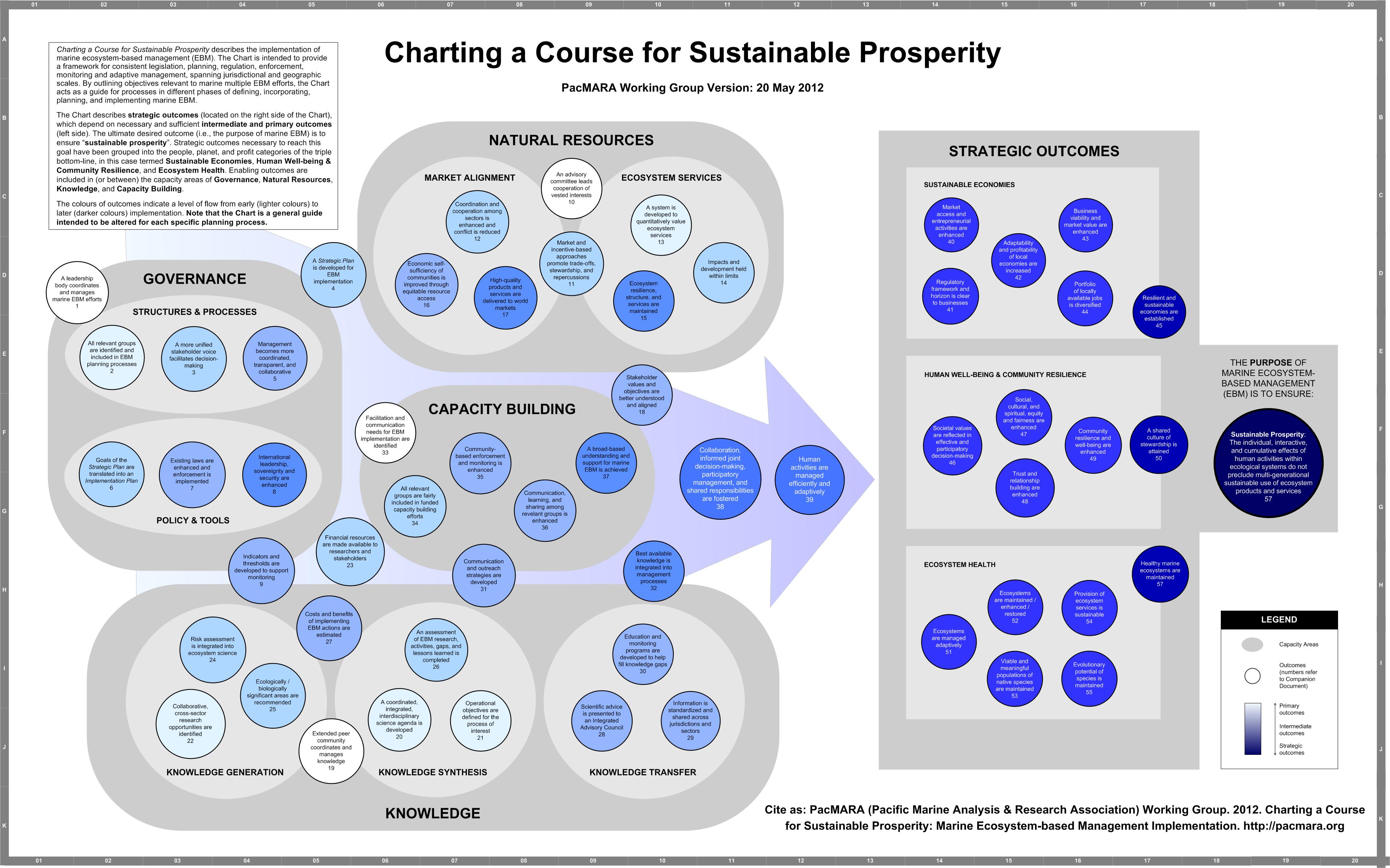
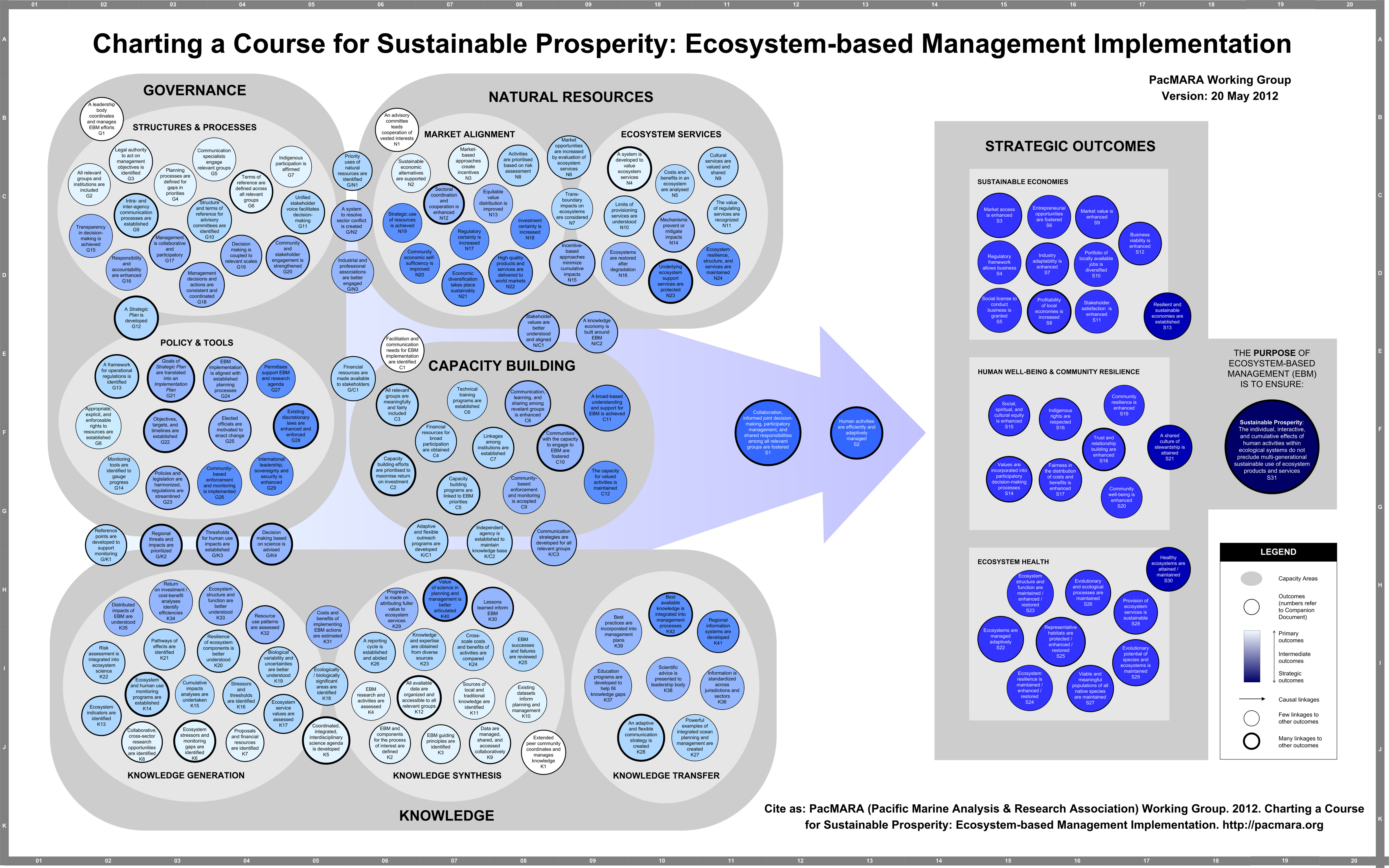
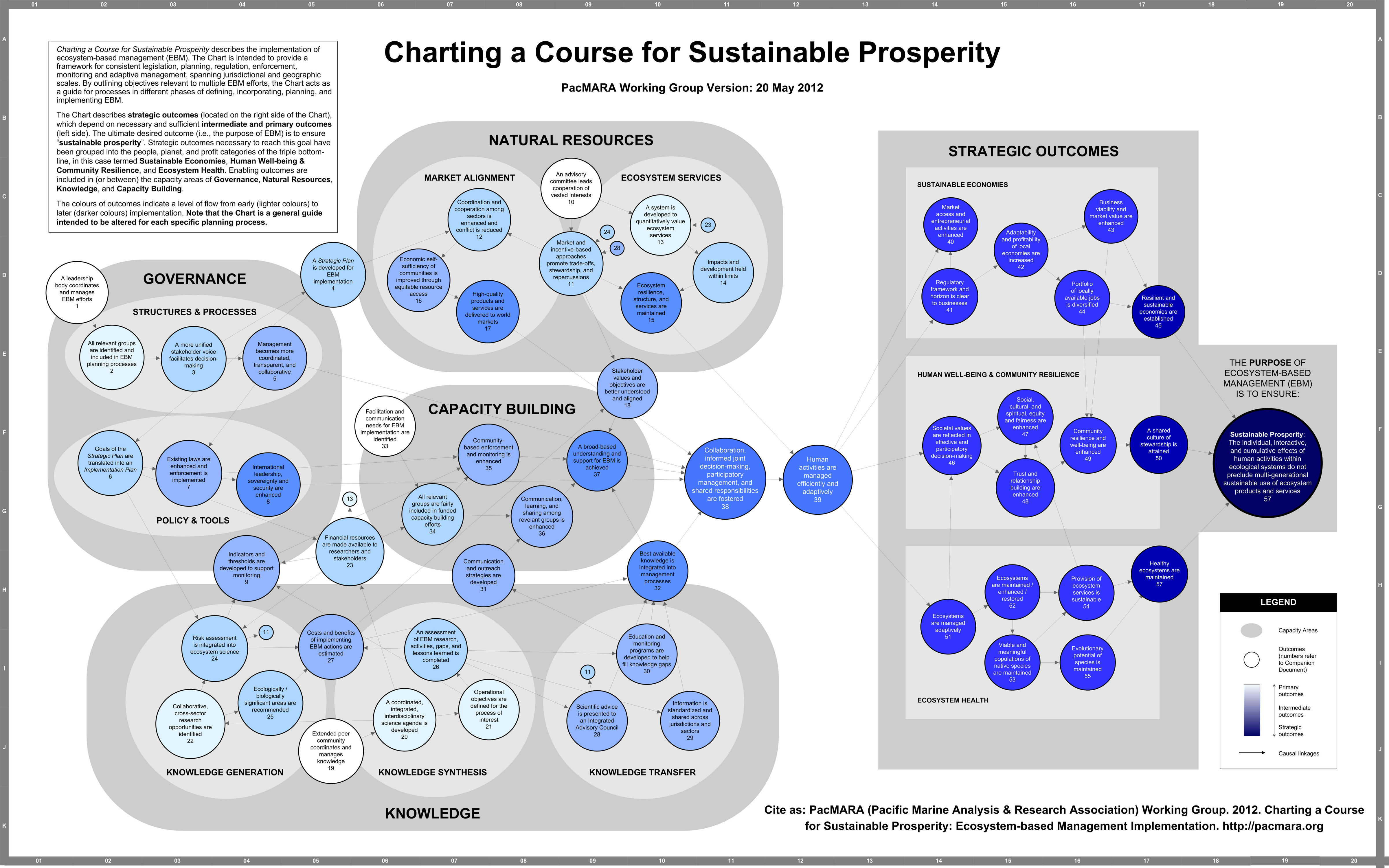
Ecosystem-based management (EBM) is critical to the sustainable use of natural resources; however, taking EBM from the conceptual to operational stage is daunting. “Charting a Course for Sustainable Prosperity” is an intuitive architecture to guide implementation of EBM. The Chart is intended to provide a framework for consistent legislation, planning, regulation, enforcement, monitoring and adaptive management, spanning jurisdictional and geographic scales. By outlining objectives relevant to marine multiple EBM efforts, the Chart acts as a guide for processes in different phases of defining, incorporating, planning, and implementing marine EBM.
The Chart describes strategic outcomes that depend on necessary and sufficient intermediate and primary outcomes. The ultimate desired outcome (i.e., the purpose of marine EBM) is to ensure “sustainable prosperity”. Strategic outcomes necessary to reach this goal have been grouped into the people, planet, and profit categories of the triple bottom-line, in this case termed Sustainable Economies, Human Well-being & Community Resilience, and Ecosystem Health. Enabling outcomes are included in (or between) the capacity areas of Governance, Natural Resources, Knowledge, and Capacity Building.
The architecture of the Chart has drawn upon success stories from the past to guide accomplishments of the future. It can be used in a number of ways, depending on the detail necessary for each management context. In its general form, the Chart can help governments and stakeholders examine key issues and align expectations around EBM components at a broad level. When further articulated in the context of a particular management problem, the Chart will help relate and explain specific aspects of resource use and conservation planning, identify and prioritise important linkages and dependencies, and direct the development of implementation plans.
The Chart was refined from outputs of the Marine EBM Implementation Workshop by: Heather Coleman (PacMARA), Edward Gregr (UBC IRES), Melissa Evanson (Fisheries and Oceans Canada), Nicholas Irving (Parks Canada), Grant Murray (Vancouver Island University), James McIsaac (Commercial Fishing Caucus), Anoma Patirana (Environment Canada), and Norma Serra-Sogas (PacMARA).
To read a short overview of the purpose and how to use the Chart, please click here.
We are all hoping that this simple gesture catches on…
I WILL WEAR GREEN
This July 1st I will wear green. I love our country and I love to celebrate it on Canada Day by proudly sporting red and white. But this year I will wear green.
I will wear green to send a message that our country’s identity is our environment. I will wear green to protest the dismantling of environmental protection through changes to the Fisheries Act and repeals of the National Round Table Act and the Canadian Environmental Assessment Act. I will wear green to protest what has been dubbed the “environmental devastation” act, bill C-38, and how we have not been consulted.
I will wear green to show that I care about our climate and I am ashamed that our government has missed all of their targets and has no adequate plan to cut emissions.
I will wear green to protest funding cuts and closures to our important centres of environmental research: the Experimental Lakes, PEARL, the Centre for Plant Health, the Bamfield Marine Science Centre, and others. I will wear green to protest cuts to Ecological Integrity Monitoring in National Parks and cuts to the Contaminants Program Fisheries and Oceans. I will wear green to protest cuts to fish habitat management at DFO. I will wear green for my health and the health of my unborn children.
I will wear green for our land, water and air. I will wear green for our climate and environment. I will wear green for our oceans. I will wear green for our wildlife, our trees, our plants, our animals, our fishes.
I will wear green for you, for me, for our future.
Why will you wear green?
If you care about our environment and want to remind our government that your voice counts too, please join us in wearing green on Canada Day.
Qmarxan is a set of simple-to-use tools developed by our very own Marxan trainer, Trevor Wiens, of Apropos Info Systems. The tool was developed to create Marxan input files within QGIS (free GIS software), allowing users to do all of the GIS work for Marxan analyses easily. Like Marxan 2.43, QGIS runs on Windows, Mac OS X, and Linux, so with Qmarxan users can run Marxan projects on the platform of choice.
With Qmarxan users can:
– create planning grids,
– measure conservation features,
– generate all input files,
– input results for viewing, and
– edit the input.dat file without the needing InEdit or Zonae Cogito.
Version 0.98.2 is currently available and described in a manual here. And Trevor has also recently translated our demonstration excel exercise, interactively illustrating how Marxan works, available here.
To use Qmarxan, install QGIS and install Qmarxan from the QGIS third party plugin repository. For help on the use of Qmarxan, please visit this site.
PRESS RELEASE from the UCSB website PacMARA and COS's Decision Guide profiles a number of tools that are used for MSP.
(Santa Barbara, Calif.) –– The ocean is becoming an increasingly crowded place. New users, such as the wind industry, compete with existing users and interests for space and resources. With the federal mandate for comprehensive ocean planning made explicit in the National Ocean Policy, the need for the transparent evaluation of potential tradeoffs is now greater than ever.
A study published in the March 5 Proceedings of the National Academy of Sciences (PNAS) shows for the first time that incorporating multiple stakeholder interests in a comprehensive approach to ocean planning (Marine Spatial Planning or MSP), actually reduces conflict and enhances cultural, conservation, and economic benefits. Using a model of Massachusetts Bay, the authors found that by designing offshore wind farms with multiple ocean users in mind, managers could prevent over $1 million in losses to the incumbent fishery and whale watching sectors, limit impacts on biodiversity conservation, and generate more than $10 billion in extra value to the wind energy sector.
Researchers at UC Santa Barbara’s Bren School of Environmental Science & Management and UCSB’s National Center for Ecological Analysis and Synthesis (NCEAS) developed MSP-minded wind farm designs and compared them to “business as usual” designs under traditional energy permitting. “This new study provides clear evidence for the value of doing MSP,” says lead author Crow White, a postdoctoral researcher at Bren. Co-author Ben Halpern, director of UCSB’s Center for Marine Assessment and Planning and research scientist at NCEAS, adds: “It also validates the efforts by Massachusetts to implement their law and strongly supports other states and the Federal government in their efforts to pursue MSP.”
Importantly, the study shows that the value of MSP increases with the size of the planning area. Even small states will benefit substantially, both financially and in avoiding unnecessary conflict, but the states with the largest coastal areas like Florida, California, Hawaii, Texas, and Alaska will benefit enormously, potentially in the trillions of dollars.
By using MSP, policymakers and managers could choose and implement a specific design that reflects society’s relative preferences for particular ocean activities. While they are often left out of economic analyses, tradeoff analysis can include those ocean uses that can only be measured in non-monetary currencies such as biodiversity conservation, recreational person-days, and cultural value. Visualization of these tradeoffs can provide greater transparency for negotiations among existing and emerging ocean uses whose diverse stakeholders may not have previously considered their effects on other sectors.
“Strangers to marine spatial planning may worry that it means getting less from the ocean tomorrow. This study shows how smarts and science can help us all wind up with a little more … forever,” says Les Kaufman, a marine biologist at Boston University and a collaborator on the broader project that includes this study.
Though these results illustrate the possibilities of MSP, the findings are not prescriptive –– this study simply suggests possibilities. Analyses of other ocean activities such as bird conservation, shipping, and liquefied natural gas development could enrich the analysis, as well as could accounting for the indirect benefits of ocean activities, such as employment and coastal waterfront activity. White says, “The more ocean uses are accounted for, the more society will benefit.”